
MAP OF THE AZORES
MAP OF THE AZORES. MOUNT - PAGE. The Western Isles. London 1715. stains, wear.
Länk till objektet hos Stockholms Auktionsverk300 SEK
Avslutade auktioner liknande MAP OF THE AZORES

Karta över Norden
Vägghängd karta över Norden. Kartografi, reproduktion & tryck Dr. Magnus Roth Mått: 210 x 155 cm Konditionsrapport: Märken, revor & bruksslitage, veck, inga övriga anmärkningar. Läs mer...
550 SEK

Anson map of South America
MAP OF SOUTH AMERICA . ANSON, GEORGE. A chart of the southern part of South America : with the track of the Centurion from the Läs mer...
2 400 SEK
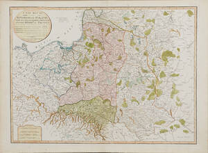
Map of Poland 1799
MAP OF POLAND. A New Map Of The Kingdom of Poland with its Dismembered Provinces and the Kingdom of Prussia, London, Laurie & Whittle, 1799. Läs mer...
1 600 SEK
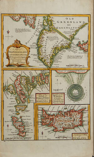
Bowen Grönland c. 1750
GREENLAND - ICELAND. BOWEN, Emanuel. A Map of Old Greenland or Öster Bygd & Wester Bygd... - A Map of the Islands of Ferro or Läs mer...
1 600 SEK

Bowen map of the North Pole c. 1750
THE NORTH POLE. BOWEN, EMANUEL. A new & accurate map of the North Pole with all the countries hitherto discovered. Situated near or adjacent to Läs mer...
1 000 SEK
Europakarta 1950-tal
Vägghängd karta över Europa. Kartografi, reproduktion & tryck: Karl Wenschow G.M.B.H Munchen. Mått: 213 x 176 cm Konditionsrapport: Märken, mindre revor & bruksslitage, Inga övriga Läs mer...
500 SEK

South America map by Blome 1690
SCARE MAP OF SOUTH AMERICA. BLOME, RICHARD. A New Mapp of America Meridionale Designed by Monsieur Sanson Geographer to the French King... London, c. Läs mer...
1 700 SEK

Robert Sayer A New Map of the Northern States
A NEW MAP OF THE NORTHERN STATES, Robert Sayer, Laurie & Whittle, London 1794, containing The Kingdoms of Sweden, Denmark and Norway, kolorerad, ca 46x64 Läs mer...
1 100 SEK

Mount - Page Spain 2 maps / charts
MOUNT-PAGE (2). A chart of the sea-coast of Spain from cape de Gata to cape S. Martin. And of the sea-coast of Barbary... London c. Läs mer...
400 SEK
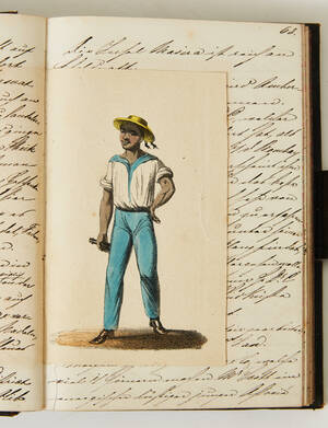
Manuscript dated Aden 1859
MANUSCRIPT. Manuscript dated Aden 17 July 1859. 256 pp. Written in German. With 24 inset colour lithograph plates (costume plates), some minor illustrations and an Läs mer...
20 000 SEK