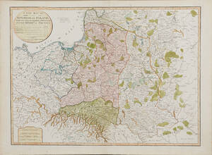
Map of Poland 1799
MAP OF POLAND. A New Map Of The Kingdom of Poland with its Dismembered Provinces and the Kingdom of Prussia, London, Laurie & Whittle, 1799. . Some folds, some spotting, small tear to upper part.
Länk till objektet hos Stockholms Auktionsverk1 600 SEK
Avslutade auktioner liknande Map of Poland 1799

18th Century Lotter maps of Poland and Russia
MAPS, (2), TOBIAS CONRAD LOTTER, Map of Northern Poland, Borussiae Regnum Complectens Circulos Sambiensem, Natangiensem et Hockerlandiae nec non Borussia Polonica Exhibens Palatinatus Culmiensem, Marienburgensem, Läs mer...
1 800 SEK
18th Century Lotter maps of Poland and Russia
MAPS, (2), TOBIAS CONRAD LOTTER, Map of Northern Poland, Borussiae Regnum Complectens Circulos Sambiensem, Natangiensem et Hockerlandiae nec non Borussia Polonica Exhibens Palatinatus Culmiensem, Marienburgensem, Läs mer...
900 SEK

Map of Poland and the Baltics 2 maps
MAP OF POLAND AND THE BALTICS (2). MAYER, JOHANN TOBIAS. Mappa geographica regni Poloniae ex novissima quotquot sunt mappis specialibus composita... Nürnberg (Homann Heirs) 1773. Läs mer...
2 400 SEK

Four 18th century maps of Eastern Europe
MAPS, (4), all published by LAURIE & WHITTLE, London:. All with central folding marks. A New Map of the Electorate of Bavaria and A New Läs mer...
1 800 SEK
Två kartor, Laurie & Whittle, London
KARTOR (2), LAURIE & WHITTLE, London, "Traveling map of Sweden proper, Gothland..." 1807, kolorerad gravyr, "A new map of the seat of war comprehending Germany,Poland...), Läs mer...
500 SEK

Map of Poland by Mayer 1773
POLAND. MAYER, TOBIAS. Carte des etats de la Covronne de Pologne... Nürnberg, Homann heirs, 1773. Centrefold, some slight creasing, dampstains to the margins, slightly affecting Läs mer...
950 SEK

Four 18th century maps of Eastern Europe
MAPS, (4), all published by LAURIE & WHITTLE, London:. All with central folding marks. A New Map of the Electorate of Bavaria and A New Läs mer...
700 SEK

Karta av Polen
MAP OF POLAND AND THE BALTICS, MAYER, JOHANN TOBIAS. Mappa geographica regni Poloniae ex novissima quotquot sunt mappis specialibus composita... Nürnberg (Homann Heirs) 1773. . Läs mer...
800 SEK
Karta över Norden
Vägghängd karta över Norden. Kartografi, reproduktion & tryck Dr. Magnus Roth Mått: 210 x 155 cm Konditionsrapport: Märken, revor & bruksslitage, veck, inga övriga anmärkningar. Läs mer...
550 SEK

Map of Ukraine etc.
MAP OF UKRAINE, BLACK SEA ETC. German engraved map with outline colour showing Ukraine, Black Sea, Caspian Sea, part of Asia and part of Russia. Läs mer...
950 SEK