
Robert Sayer A New Map of the Northern States
A NEW MAP OF THE NORTHERN STATES, Robert Sayer, Laurie & Whittle, London 1794, containing The Kingdoms of Sweden, Denmark and Norway, kolorerad, ca 46x64 cm. Mittenveck.
Länk till objektet hos Stockholms Auktionsverk1 100 SEK
Avslutade auktioner liknande Robert Sayer A New Map of the Northern States

Sayer The Northern states 1772
SAYER, ROBERT. A New Map of the Northern States Containing the Kingdoms of Sweden, Denmark, and Norway, with the Western Parts of Russia, Livonia, Courland Läs mer...
1 100 SEK

Sayer The Northern states 1772
SAYER, ROBERT. A New Map of the Northern States Containing the Kingdoms of Sweden, Denmark, and Norway, with the Western Parts of Russia, Livonia, Courland Läs mer...
1 000 SEK

En samlares bibliotek, del 16. En grupp böcker om...
Bestående av; Ma Shaoxuan, Inside-Paintind Snuff Bottle, Robert Hall, Chinese Snuff Bottles, volume I, II, III, IV. Hugh Moss, Chinese Snuff Bottles. I-IV. Moss, Chinese Läs mer...
7 100 SEK

Robert Zuckerman
Robert Zuckerman, "David Bowie, Coney Island, New York", 1990 Signerad på etikett a tergo. Upplaga 2/50. Archival ink print, bildyta 47 x 70 cm. Ej Läs mer...
19 500 SEK
Robert Zuckerman
Robert Zuckerman, "Star Wars Marquee, Albuquerque, New Mexico", 1977 Signerad på etikett a tergo. Upplaga 4/50. Archival ink print, bildyta 70 x 70 cm. Ej Läs mer...
15 500 SEK
Robert Zuckerman
Robert Zuckerman, fotografi, numrerad 6/50, signerad a tergo. "David Bowie, Coney Island, New York". Archival ink print, bildmått 48 x 71,5 cm. Ej examinerad ur Läs mer...
14 500 SEK

Wall map of Germany by Delarochette c. 1790
WALL MAP OF GERMANY. DELAROCHETTE, LOUIS STANISLAS D´ARCY. Map of the Empire of Germany, including all the states comprehended under that name: with the kingdom Läs mer...
650 SEK

South America map by Blome 1690
SCARE MAP OF SOUTH AMERICA. BLOME, RICHARD. A New Mapp of America Meridionale Designed by Monsieur Sanson Geographer to the French King... London, c. Läs mer...
1 700 SEK
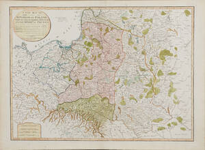
Map of Poland 1799
MAP OF POLAND. A New Map Of The Kingdom of Poland with its Dismembered Provinces and the Kingdom of Prussia, London, Laurie & Whittle, 1799. Läs mer...
1 600 SEK

Wall map of Germany by Delarochette c. 1790
WALL MAP OF GERMANY. DELAROCHETTE, LOUIS STANISLAS D´ARCY. Map of the Empire of Germany, including all the states comprehended under that name: with the kingdom Läs mer...
4 000 SEK