
Laurie and Whittels map of Sweden 1823
LAURIE AND WHITTLE. A new Travelling Map of Sweden proper, Gothland, &c. Exhibiting the admeasured Distances, on all the Principal and Cross Roads, in Quarters of a Swedish Mile. London (Richd. Holmes Laurie) 1823.Engraved old coloured map, about 625x495 mm. Wide margins. Some marginal wearing. Some spotting in the margins.
Länk till objektet hos http://www.stadsauktion.se700 SEK
Avslutade auktioner liknande Laurie and Whittels map of Sweden 1823

Laurie and Whittels map of Sweden 1823
LAURIE AND WHITTLE. A new Travelling Map of Sweden proper, Gothland, &c. Exhibiting the admeasured Distances, on all the Principal and Cross Roads, in Quarters Läs mer...
1 300 SEK

Laurie & Whittle The Northern states 1772
SCANDINAVIA. LAURIE - WHITTLE. A New Map of the Northern States Containing the Kingdoms of Sweden, Denmark, and Norway, with the Western Parts of Russia, Läs mer...
2 200 SEK
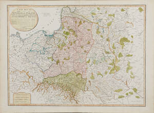
Map of Poland 1799
MAP OF POLAND. A New Map Of The Kingdom of Poland with its Dismembered Provinces and the Kingdom of Prussia, London, Laurie & Whittle, 1799. Läs mer...
1 600 SEK

Laurie & Whittle Traveling map of Sweden 1807
LAURIE & WHITTLE. New travelling map of Sweden proper, Gothland... London, 1807. Mittveck som vanligt, några smärre revor i marginal, några småfläckar. Läs mer...
300 SEK

Robert Sayer A New Map of the Northern States
A NEW MAP OF THE NORTHERN STATES, Robert Sayer, Laurie & Whittle, London 1794, containing The Kingdoms of Sweden, Denmark and Norway, kolorerad, ca 46x64 Läs mer...
1 100 SEK

Karta Västerbotten 1800-tal
Karta över Västerbottens län Sammandragen och författad av P.A Kjellerstedt 1870-1878 Kartans mått: 100 x 71 cm Konditionsrapport: Bruks- och åldersbaserat slitage, veck, revor och Läs mer...
550 SEK

Four 18th century maps of Eastern Europe
MAPS, (4), all published by LAURIE & WHITTLE, London:. All with central folding marks. A New Map of the Electorate of Bavaria and A New Läs mer...
1 800 SEK

Två kartor, Laurie & Whittle, London
KARTOR (2), LAURIE & WHITTLE, London, "Traveling map of Sweden proper, Gothland..." 1807, kolorerad gravyr, "A new map of the seat of war comprehending Germany,Poland...), Läs mer...
500 SEK

Three maps of The Netherlands and South America
MAPS, (3), all published by LAURIE & WHITTLE, London:. All with central folding marks and margin tears to the fold. A new map of the Läs mer...
1 400 SEK

Karta Sverige Laurie Whittle
MAP OF SWEDEN. LAURIE AND WHITTLE. A new Travelling Map of Sweden proper, Gothland, &c. Exhibiting the admeasured Distances, on all the Principal and Cross Läs mer...
1 200 SEK