
Map of part of France by Blaeu 17th century
MAP OF AVIGNON, RIVER RHONE AND SURROUNDINGS. BLAEU, WILLEM. La Principauté d´Orange et Comtat de Venaissin 1627. Amsterdam, c. 1640-60. Folds.
Länk till objektet hos Stockholms Auktionsverk1 300 SEK
Avslutade auktioner liknande Map of part of France by Blaeu 17th century

Map of Ukraine etc.
MAP OF UKRAINE, BLACK SEA ETC. German engraved map with outline colour showing Ukraine, Black Sea, Caspian Sea, part of Asia and part of Russia. Läs mer...
950 SEK
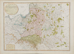
Map of Poland 1799
MAP OF POLAND. A New Map Of The Kingdom of Poland with its Dismembered Provinces and the Kingdom of Prussia, London, Laurie & Whittle, 1799. Läs mer...
1 600 SEK

Anson map of South America
MAP OF SOUTH AMERICA . ANSON, GEORGE. A chart of the southern part of South America : with the track of the Centurion from the Läs mer...
2 400 SEK

Bowen Scandinavia ca 1760
BOWEN, E. A New and Accurate Map of Scandinavia or the Northern Crowns of Sweden, Denmark and Norway. A Map of Spitzbergen or Greenland, Iceland Läs mer...
1 700 SEK

South America map by Blome 1690
SCARE MAP OF SOUTH AMERICA. BLOME, RICHARD. A New Mapp of America Meridionale Designed by Monsieur Sanson Geographer to the French King... London, c. Läs mer...
1 700 SEK

A New Map of Part of the United States
JOHN CARY, "A New Map of Part of the United States of North America, containing those of New York, Vermont, New Hampshire...etc", 1806, dagermått ca Läs mer...
600 SEK

Bowen map of the North Pole c. 1750
THE NORTH POLE. BOWEN, EMANUEL. A new & accurate map of the North Pole with all the countries hitherto discovered. Situated near or adjacent to Läs mer...
1 000 SEK

Map of Augsburg Ostertag 1719
MAP OF AUGSBURG. OSTERTAG, HEINRICH JOHAN - BAECK, ELIAS - WOLFF, JEREMIAS. Augusta Vindelicorum. Augsburg 1719. Rolled, folds, tears and repairs to upper and lower Läs mer...
3 200 SEK

Map - Sea chart Bellin Atlantic ocean 1766
SEA CHART ATLANTIC OCEAN. BELLIN, Jacques Nicolas. Carte Reduite de l´Ocean Occidental. Quatrieme Edition. Paris, Depot de la Marine, 1766. Centrefold as issued, folds, spotting Läs mer...
4 000 SEK

Hans Hedberg 1917-2007 Skulptur 'Ägg' 1900-tal
Tvådelad skulptur stående på sockel i form av ett ägg, Starkeldsfajans med spräcklig glasyr i gröna och vita toner. Signerad: HHg Biot, Frankrike. Höjd med Läs mer...
5 800 SEK