
Map of Poland by Mayer 1773
POLAND. MAYER, TOBIAS. Carte des etats de la Covronne de Pologne... Nürnberg, Homann heirs, 1773. Centrefold, some slight creasing, dampstains to the margins, slightly affecting the plate mark. Some reinforcements on verso.
Länk till objektet hos Stockholms Auktionsverk950 SEK
Avslutade auktioner liknande Map of Poland by Mayer 1773
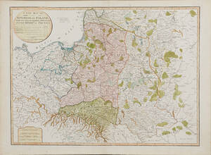
Map of Poland 1799
MAP OF POLAND. A New Map Of The Kingdom of Poland with its Dismembered Provinces and the Kingdom of Prussia, London, Laurie & Whittle, 1799. Läs mer...
1 600 SEK

Map of Poland and the Baltics 2 maps
MAP OF POLAND AND THE BALTICS (2). MAYER, JOHANN TOBIAS. Mappa geographica regni Poloniae ex novissima quotquot sunt mappis specialibus composita... Nürnberg (Homann Heirs) 1773. Läs mer...
2 400 SEK

18th Century Lotter maps of Poland and Russia
MAPS, (2), TOBIAS CONRAD LOTTER, Map of Northern Poland, Borussiae Regnum Complectens Circulos Sambiensem, Natangiensem et Hockerlandiae nec non Borussia Polonica Exhibens Palatinatus Culmiensem, Marienburgensem, Läs mer...
1 800 SEK

Karta av Polen
MAP OF POLAND AND THE BALTICS, MAYER, JOHANN TOBIAS. Mappa geographica regni Poloniae ex novissima quotquot sunt mappis specialibus composita... Nürnberg (Homann Heirs) 1773. . Läs mer...
800 SEK

Four 18th century maps of Eastern Europe
MAPS, (4), all published by LAURIE & WHITTLE, London:. All with central folding marks. A New Map of the Electorate of Bavaria and A New Läs mer...
1 800 SEK

Karta Västerbotten 1800-tal
Karta över Västerbottens län Sammandragen och författad av P.A Kjellerstedt 1870-1878 Kartans mått: 100 x 71 cm Konditionsrapport: Bruks- och åldersbaserat slitage, veck, revor och Läs mer...
550 SEK

Mayer Gulf of Finland 1751 Sinus Finnici
THE GULF OF FINLAND. MAYER, JOHANN TOBIAS - HOMANN HEIRS. Sinus Finnici delineatio geographica... /Partie Occidentale du Golfe de Finnland, ou sunt representées les cotes Läs mer...
2 000 SEK

Anson map of South America
MAP OF SOUTH AMERICA . ANSON, GEORGE. A chart of the southern part of South America : with the track of the Centurion from the Läs mer...
2 400 SEK

South America map by Blome 1690
SCARE MAP OF SOUTH AMERICA. BLOME, RICHARD. A New Mapp of America Meridionale Designed by Monsieur Sanson Geographer to the French King... London, c. Läs mer...
1 700 SEK
18th Century Lotter maps of Poland and Russia
MAPS, (2), TOBIAS CONRAD LOTTER, Map of Northern Poland, Borussiae Regnum Complectens Circulos Sambiensem, Natangiensem et Hockerlandiae nec non Borussia Polonica Exhibens Palatinatus Culmiensem, Marienburgensem, Läs mer...
900 SEK