
Jaillot map of the Sound 1693-1750
THE SOUND - ÖRESUND. JAILLOT, A. H. Carte de detroit du sond contenant les costes de l´Isle de Zélande comprises entre Nicopen et l´isle de Meun et celles du Schonen, depuis la ponte de Kol, jusqu´a Valsterbon. Paris, Depot de la Marine (1693-c. 1750). Centrefold, small spot.
Länk till objektet hos Stockholms Auktionsverk1 800 SEK
Avslutade auktioner liknande Jaillot map of the Sound 1693-1750

Öresund karta av Jaillot ca 1690
THE SOUND - ÖRESUND. (JAILLOT, HUBERT A.) Carte de detroit du sond contenant les costes de l'Isle de Zélande comprises entre Nicopen et l'isle de Läs mer...
1 900 SEK
Karta över Norden
Vägghängd karta över Norden. Kartografi, reproduktion & tryck Dr. Magnus Roth Mått: 210 x 155 cm Konditionsrapport: Märken, revor & bruksslitage, veck, inga övriga anmärkningar. Läs mer...
550 SEK

*Lp skivor 4 st album
1 st album the best of James last 6 skivor 1 st album Stereo spectualar 9 st skivor 1 st album The sound of Broadway Läs mer...
45 SEK

Anson map of South America
MAP OF SOUTH AMERICA . ANSON, GEORGE. A chart of the southern part of South America : with the track of the Centurion from the Läs mer...
2 400 SEK
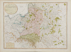
Map of Poland 1799
MAP OF POLAND. A New Map Of The Kingdom of Poland with its Dismembered Provinces and the Kingdom of Prussia, London, Laurie & Whittle, 1799. Läs mer...
1 600 SEK
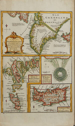
Bowen Grönland c. 1750
GREENLAND - ICELAND. BOWEN, Emanuel. A Map of Old Greenland or Öster Bygd & Wester Bygd... - A Map of the Islands of Ferro or Läs mer...
1 600 SEK
Europakarta 1950-tal
Vägghängd karta över Europa. Kartografi, reproduktion & tryck: Karl Wenschow G.M.B.H Munchen. Mått: 213 x 176 cm Konditionsrapport: Märken, mindre revor & bruksslitage, Inga övriga Läs mer...
500 SEK

Steel map of the Baltic 1818
CHART OF THE BALTIC. STEEL, (J). New and accurate chart of the Baltic, including particular plans of the entrances to Stockholm, Wingoe Sound and Gothaborg, Läs mer...
1 900 SEK

South America map by Blome 1690
SCARE MAP OF SOUTH AMERICA. BLOME, RICHARD. A New Mapp of America Meridionale Designed by Monsieur Sanson Geographer to the French King... London, c. Läs mer...
1 700 SEK

Bowen map of the North Pole c. 1750
THE NORTH POLE. BOWEN, EMANUEL. A new & accurate map of the North Pole with all the countries hitherto discovered. Situated near or adjacent to Läs mer...
1 000 SEK