
Oldest printed map of Denmark c. 1590
OLDEST PRINTED MAP OF DENMARK. BRAUN, GEORG - HOGENBERG, FRANS - JORDAN, MARCUS. Danorum Marca, uel Cimbricum, aut Daniae Regnum... Cologne about 1590. See text.
Länk till objektet hos Stockholms Auktionsverk3 000 SEK
Avslutade auktioner liknande Oldest printed map of Denmark c. 1590

Map of Denmark c. 1635 Braun-Hogenberg
OLDEST PRINTED MAP OF DENMARK. BRAUN, GEORG - HOGENBERG, FRANS - JORDAN, MARCUS. Danorum Marca, uel Cimbricum, aut Daniae Regnum... Cologne c. 1635. Lacking small Läs mer...
4 400 SEK

Otto Nielsen, affisch 'by SAS Scandinavian Airline...
Motiv med House of Parliment / Palace of Westminster, London. Printed in Denmark by Offset Axel Andreasen & Sönner Copenhagen. 102 x 64 cm. Oramad. Läs mer...
2 200 SEK

Anson map of South America
MAP OF SOUTH AMERICA . ANSON, GEORGE. A chart of the southern part of South America : with the track of the Centurion from the Läs mer...
2 400 SEK
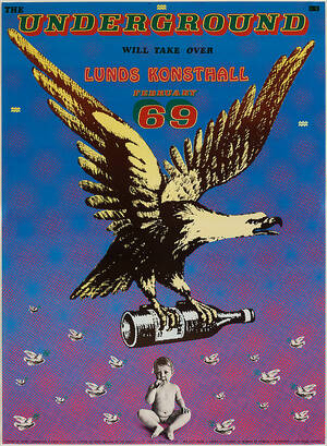
Sture Johannesson
Sture Johannesson, "The Underground will take over Lunds Konsthall February 69". Utställningsaffisch. "Poster by Sture Johannesson & Pablo Picasso - Picture of sweet Malinda by Läs mer...
2 600 SEK

Map of Denmark, Danorum Marca c. 1590
OLDEST PRINTED MAP OF DENMARK. BRAUN, GEORG - HOGENBERG, FRANS - JORDAN, MARCUS. Danorum Marca, uel Cimbricum, aut Daniae Regnum... Cologne about 1590. 296307. Läs mer...
9 200 SEK
Alex Secher og Henry Thelander. To vintage plakate...
Alex Secher (1913-1989). Vintage dansk turist plakat Visit Denmark, motiv med Jellingesten og vikinger, litografisk trykt hos Andreasen & Lachman. Sign. i trykket Alex Secher Läs mer...
350 DKK

Bowen Scandinavia ca 1760
BOWEN, E. A New and Accurate Map of Scandinavia or the Northern Crowns of Sweden, Denmark and Norway. A Map of Spitzbergen or Greenland, Iceland Läs mer...
1 700 SEK
Henry Thelander. Vintage plakat med Danmarks konge...
Henry Thelander (1902-1986). Plakat med Danmarks kongerække Once upon a time - a thousand years ago - there was a king of Denmark named Gorm Läs mer...
500 DKK

Robert Sayer A New Map of the Northern States
A NEW MAP OF THE NORTHERN STATES, Robert Sayer, Laurie & Whittle, London 1794, containing The Kingdoms of Sweden, Denmark and Norway, kolorerad, ca 46x64 Läs mer...
1 100 SEK
Bonne´s Map of Egypt 1762
RIGOBERT BONNE (France 1727-1794), Carte de l´Egypte Ancienne et Moderne, Paris 1762, printed by Lattré, engraved map with cartouche, coloured, covering Egypt from the Nile Läs mer...
450 SEK