
Rare map of the battle of Poltava
KARL XII - CHARLES XII. BATTLE OF POLTAVA 1709. LEOPOLD, JOSEPH FRIEDERICH. Grundriss der glorieusen Action, welche in der Gegend Pultawa in der Ucraine zwischen der Armee Sner. Czarischen Maÿ. Petri dess Ersten Keÿsern von Gross-Russland und Seiner Königl. May. in Schweden Caroli XII. den 27 Juny, 8. Juli Annô 1709 vorgegangen. Augsburg 1709. 232256.
Länk till objektet hos Stockholms Auktionsverk6 400 SEK
Avslutade auktioner liknande Rare map of the battle of Poltava

Karta över Norden
Vägghängd karta över Norden. Kartografi, reproduktion & tryck Dr. Magnus Roth Mått: 210 x 155 cm Konditionsrapport: Märken, revor & bruksslitage, veck, inga övriga anmärkningar. Läs mer...
550 SEK

Dudley´s rare map of the Baltic 1646
LARGE RARE MAP OF THE BALTIC 1646. DUDLEY, ROBERT. Carta particolare dell mare Baltico che comincia con il capo de Eleeholm in Suezia, e Finisce Läs mer...
15 000 SEK

Rare map of the Gulf of Finland by Åkerman
RARE MAP OF THE GULF OF FINLAND. ÅKERMAN, ANDERS (1721-1778). Mappa hydrographica exhibens Sinum Finnicum, eller hydrographisk charta öfwer Finska viken. No place, 1768. . Läs mer...
4 000 SEK

Anson map of South America
MAP OF SOUTH AMERICA . ANSON, GEORGE. A chart of the southern part of South America : with the track of the Centurion from the Läs mer...
2 400 SEK

Rare map of Southern United States 1824
RARE MAP OF SOUTHERN UNITED STATES - MELISH, JOHN - KLINCKOWSTRÖM, AXEL LEONARD. Southern Section of the United States including Florida &c. 1824. . See Läs mer...
4 000 SEK
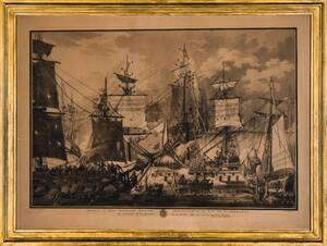
Johan Fredrik Martin 1755-1816 Gravyr
Avdrag från 1800/1900-tal, efter J.L Deprez visande svenska chefsskeppet Gustaf III vid slaget vid Hogland 1788. Plåtmått: 73 x 51 cm Mått inklusive ram: 87 Läs mer...
700 SEK
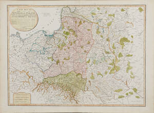
Map of Poland 1799
MAP OF POLAND. A New Map Of The Kingdom of Poland with its Dismembered Provinces and the Kingdom of Prussia, London, Laurie & Whittle, 1799. Läs mer...
1 600 SEK

PRUSSIAN BAYONET
m/1860, blade by W KLAUBERG SOLINGEN, back of blade FW61 (1861), scabbard, marked IWD, 63,5 cm Probably from SMS Albatross (1907) a German minelaying cruiser. Läs mer...
6 600 SEK
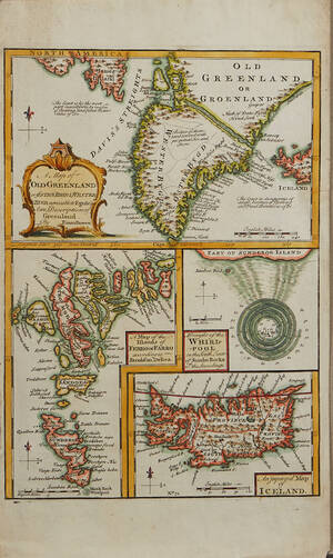
Bowen Grönland c. 1750
GREENLAND - ICELAND. BOWEN, Emanuel. A Map of Old Greenland or Öster Bygd & Wester Bygd... - A Map of the Islands of Ferro or Läs mer...
1 600 SEK
Piquet large map of Paris 1804
LARGE MAP OF PARIS. PIDQUET, CHARLES. Plan routier de la ville de Paris et de ses faubourgs, où se trouvent indiqués tous les changements opérés Läs mer...
3 200 SEK