
Blome Map of Ireland c. 1673
MAP OF IRELAND. BLOME, RICHARD. A mapp of the kingdome of Ireland. C. 1673. Narrow margins, has been folded, some spotting to upper corners.
Länk till objektet hos Stockholms Auktionsverk2 400 SEK
Avslutade auktioner liknande Blome Map of Ireland c. 1673

South America map by Blome 1690
SCARE MAP OF SOUTH AMERICA. BLOME, RICHARD. A New Mapp of America Meridionale Designed by Monsieur Sanson Geographer to the French King... London, c. Läs mer...
1 700 SEK

Map of Ukraine etc.
MAP OF UKRAINE, BLACK SEA ETC. German engraved map with outline colour showing Ukraine, Black Sea, Caspian Sea, part of Asia and part of Russia. Läs mer...
950 SEK

World map by Danckerts c. 1680
WORLD MAP. DANCKERTS, JUSTUS. Nova Totius Terrarum Orbis Tabula. Amsterdam C. 1680. Map trimmed into plate area, lacking a few millimeters of plate, no margins. Läs mer...
17 000 SEK
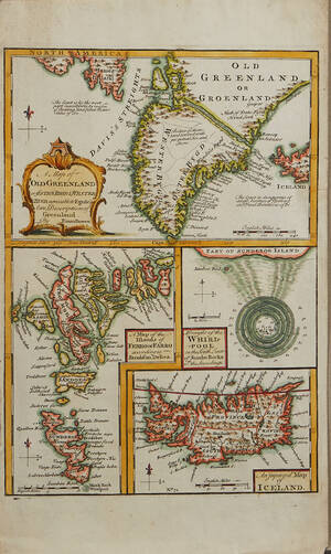
Bowen Grönland c. 1750
GREENLAND - ICELAND. BOWEN, Emanuel. A Map of Old Greenland or Öster Bygd & Wester Bygd... - A Map of the Islands of Ferro or Läs mer...
1 600 SEK

18th century map of Ireland
MAP OF IRELAND, Hiberniae Regnum tam in Praecipuas Ultoniae, Connaciae, Laceniae et Momoniae quam in Minores Earundem Provincias... printed by J. H. Homann, Nürnberg, around Läs mer...
600 SEK

MAP OF IRELAND
MAP OF IRELAND. LAURIE & WHITTLE. A New Map of Ireland Compiled from Actual Surveys... 490926. Läs mer...
800 SEK

Map of Switzerland Scheuchzer c. 1735
MAP OF SWITZERLAND. SCHEUCHZER, JOHANN JAKOB. Nouvelle carte de la Suisse. Divisées en ses treize cantons... Amsterdam, Covens & Mortier (c. 1735). Partly browned. Läs mer...
5 200 SEK

Bowen map of the North Pole c. 1750
THE NORTH POLE. BOWEN, EMANUEL. A new & accurate map of the North Pole with all the countries hitherto discovered. Situated near or adjacent to Läs mer...
1 000 SEK

Mount - Page Spain 2 maps / charts
MOUNT-PAGE (2). A chart of the sea-coast of Spain from cape de Gata to cape S. Martin. And of the sea-coast of Barbary... London c. Läs mer...
400 SEK

Map of Japan, Korea Le Rouge
MAP OF JAPAN, KOREA. LE ROUGE, G. L. Carte du Japon et de la Corée. Paris c. 1750. Centrefold as issued. Some spotting, Stain to Läs mer...
850 SEK