
Moll Scandinavia c. 1710 and Trusler
MINIATURE MAPS OF SCANDINAVIA (2). MOLL, HERMAN. Scandinavia or the kingdoms of Denmark, Sueden, Norway & Lapland. London c. 1710. Moll -Trimmed to right platemark.
Länk till objektet hos Stockholms Auktionsverk300 SEK
Avslutade auktioner liknande Moll Scandinavia c. 1710 and Trusler

Early map of Scandinavia by Quad c. 1598
SCANDINAVIA. QUAD, MATTHIAS. Septentrionalium regionum Svetiae Gothiae Norvegiae Daniae. Cologne c. 1598. Centrefold as published, 2 small repaired tears, a few small tears or repaired Läs mer...
1 900 SEK

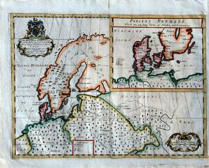
Sweden and Norway map by Gibson
MAP OF SCANDINAVIA. (GIBSON, JOHN). Sweden and Norway. London c. 1760. Folds as issued. Some offsetting. Platemark with repair on verso. Läs mer...
550 SEK

Senex karta Scandinavia ca 1720
KARTA SKANDINAVIEN. SENEX, JOHN. Scandinavia and it´s confines in which are the kingdom´s of Sweden, Norway &c... Revised by I. Senex. London 1719 (1721). Upplimmad Läs mer...
4 800 SEK

Wells A New Map of Denmark 1700
MAP OF SCANDINAVIA AND RUSSIA. WELLS, EDWARD. A New Map of Denmark, Norway, Sweden & Moscovy, Shewing their Present General Divisions, Chief Cities or Towns, Läs mer...
750 SEK

Senex, Scandinavia
KARTA SKANDINAVIEN. SENEX, JOHN. Scandinavia and it´s confines in which are the kingdom´s of Sweden, Norway &c... Revised by I. Senex. London 1719 (1721). 405940. Läs mer...
3 000 SEK
![Herman Moll Engraved and handcoloured chart entitled A Chart Of The Baltic Or East Sea, Gulf Of Finland [...] London 18th century [1745].](https://img.bruun-rasmussen.dk/g/BRFull/Arkiv/Online/1323/br_1191015_300x300.jpg)
Herman Moll: Engraved and handcoloured chart entit...
Engraved and handcoloured chart entitled A Chart Of The Baltic Or East Sea, Gulf Of Finland [...] London 18th century [1745]. C. 35 x 48 Läs mer...
650 DKK
Edward Wells: A new map of ancient Scandinavia, to...
Engraved and handcoloured map entitled A new map of ancient Scandinavia, together with as much more of ye northern part of ancient Europe as answers Läs mer...
800 DKK