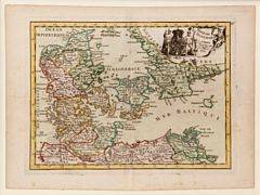
Engraved and handcoloured map of Denmark: Royaume de Danemarck. 1767. + 3 items. (4)
Engraved and handcoloured map of Denmark: Royaume de Danemarck. 1767. Size of plate: 21 x 28,5 cm. + 3 other engravings, various motifs, various sizes. (4)
Länk till objektet hos http://www.bruun-rasmussen.dk - Baltikavej1 350 DKK
Avslutade auktioner liknande Engraved and handcoloured map of Denmark: Royaume de Danemarck. 1767. + 3 items. (4)

Map of Ukraine etc.
MAP OF UKRAINE, BLACK SEA ETC. German engraved map with outline colour showing Ukraine, Black Sea, Caspian Sea, part of Asia and part of Russia. Läs mer...
950 SEK

Engraved and handcoloured map: Lalandiæ et Falstr...
Engraved and handcoloured map: Lalandiæ et Falstriæ Accurata Descriptio. 1647. Map of Lolland and Falster. Size of plate: 41 x 53 cm. + Engraved handcoloured Läs mer...
2 900 DKK
Denmark: Engraved and handcoloured (in out line) m...
Engraved and handcoloured (in out line) map of Denmark. 17th century. Size of plate: 11 x 13. Framed. + Engraved and handcoloured map of Sweden Läs mer...
1 600 DKK
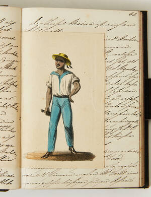
Manuscript dated Aden 1859
MANUSCRIPT. Manuscript dated Aden 17 July 1859. 256 pp. Written in German. With 24 inset colour lithograph plates (costume plates), some minor illustrations and an Läs mer...
20 000 SEK
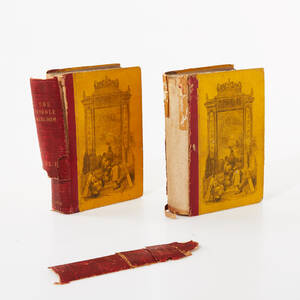
China 1848, 2 vol.
CHINA 1848 (2). WILLIAMS, SAMUEL WELLS. The Middle Kingdom, a Survey of the Geography, Government, Education, Social Liofe, Arts, Religion, &c. of the Chinese Empire Läs mer...
400 SEK

Karta Västerbotten 1800-tal
Karta över Västerbottens län Sammandragen och författad av P.A Kjellerstedt 1870-1878 Kartans mått: 100 x 71 cm Konditionsrapport: Bruks- och åldersbaserat slitage, veck, revor och Läs mer...
550 SEK

China 1848, 2 vol.
CHINA 1848 (2). WILLIAMS, SAMUEL WELLS. The Middle Kingdom, a Survey of the Geography, Government, Education, Social Liofe, Arts, Religion, &c. of the Chinese Empire Läs mer...
950 SEK

China 1848, 2 vol.
CHINA 1848 (2). WILLIAMS, SAMUEL WELLS. The Middle Kingdom, a Survey of the Geography, Government, Education, Social Liofe, Arts, Religion, &c. of the Chinese Empire Läs mer...
1 700 SEK
Folke Bengtsson 'Djurkarta' Renhud 1970
Folke Bengtsson, Luleå "Djurkarta över Norrbottens län" Djurkarta tillverkad i graverad renhud Signerad: Folke Bengtsson Daterad: 1970 Höjd: 90 cm Bredd: 65 cm Konditionsrapport: Inga Läs mer...
4 000 SEK
Pieter Van der Keere: Fionia Militaria Germa. comm...
Pieter van der Keere: Engraved and handcoloured map entitled Fionia Militaria Germa. commu. Mid. 17th century. C. 18 x 25 cm. + Henri du Sauzet: Läs mer...
800 DKK