![William Faden Chart of the Straits Between Denmark and Sweden, [...]. London 1801. Framed.](/common/images/no-image4.svg)
William Faden: "Chart of the Straits Between Denmark and Sweden, [...]. London 1801. Framed.
Engraved and handcolured in outline chart"Chart of the Straits Between Denmark and Sweden, Shewing The Passage From the Kattegat Through the Sound [... ]. London 1801. Measure of plate: 37 x 59 cm. Framed.
Länk till objektet hos http://www.bruun-rasmussen.dk - Baltikavej900 DKK
Avslutade auktioner liknande William Faden: "Chart of the Straits Between Denmark and Sweden, [...]. London 1801. Framed.

Karta publicerad av W.Faden London England 1801
"Chart of the straits between Denmark and Sweden", bildyta 66x41,5 cm Ej examinerad ur ram. Gulnad. Läs mer...
1 900 SEK

Nordenankar Öresund 1801
ÖRESUND - THE SOUND. NORDENANKAR, J. - LOUS, C. C. Chart of the Straits between Denmark and Sweden, shewing the Passage from the Kattegat through Läs mer...
750 SEK

Karta The North Sea with The Kattegat 1813
KARTA, "The North Sea with The Kattegat from the Chart of Messrs. De Verdun, Borda and Pingre", made public in 1777 By order of Louis Läs mer...
500 SEK
William Faden: The North Sea with The Kattegat fro...
William Faden: Engraved chart entitled The North Sea with The Kattegat from the Chart of Messrs. De Verdun, Borda and Pingre made Publice in 1777 Läs mer...
600 DKK

Bok, Sailing directions for Kattegat, 1800, med gr...
Sailing directions for the Kattegat to be used with the new improved chart containing descriptions of the lights, soundings, grounds and shoals […] published from Läs mer...
6 000 SEK

William Faden. London. A Map of the Kingdom of Den...
William Faden. A Map of the Kingdom of Denmark, with the Duchy of Holstein. London, 1790. Handkoloriert, auf Bütten gedruckt mit Schifffahrts- und Bahnstrassen. Maße Läs mer...
60 EUR

Karta, "Chart of The North & Baltic Seas".
Utgiven av George Philip & Son 1852, Liverpool. Bildstorlek 48 x 60 cm. Åldersrelaterat slitage. Mjuka veck. Läs mer...
220 EUR

Anson map of South America
MAP OF SOUTH AMERICA . ANSON, GEORGE. A chart of the southern part of South America : with the track of the Centurion from the Läs mer...
2 400 SEK
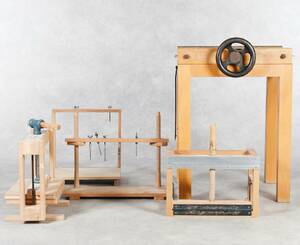
Bokbinderiverktyg och Material 1900-tal
En större samling verktyg, material, och handverktyg samt böcker om Bokbinderi. Klosspress, linjal, dekorativt papper för omslag m.m. Aldren A. Watson "Binda böcker som hobby" Läs mer...
1 300 SEK
Karta Guyana 1783
KARTA, The Coast from the Oroonoko to the river of Amazons and the inland parts, tryckt London 1783, gravyr av William Faden, mäter ca 56x81 Läs mer...
1 000 SEK