Ottens map of the Caspian Sea
RUSSIA. CASPIAN SEA. OTTENS, REINER. Nova ac verissima maris Caspii... jussu invivtissimi principis Petri Alexii Fil. magni Russorum imperatoris. Amsterdam (widow of J. Ottens) 1723.Hand coloured engraved map with figurative cartouche, about 490x605 mm. Engraved by J. Keyser. Two clean tears to centre folding, repaired, some minor tears to margin.
Länk till objektet hos http://www.stadsauktion.se700 SEK
Avslutade auktioner liknande Ottens map of the Caspian Sea

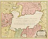
Map of Ukraine etc.
MAP OF UKRAINE, BLACK SEA ETC. German engraved map with outline colour showing Ukraine, Black Sea, Caspian Sea, part of Asia and part of Russia. Läs mer...
950 SEK

Ottens map of the Caspian Sea
RUSSIA. CASPIAN SEA. OTTENS, REINER. Nova ac verissima maris Caspii... jussu invivtissimi principis Petri Alexii Fil. magni Russorum imperatoris. Amsterdam (widow of J. Ottens) 1723. Läs mer...
800 SEK

Map by Ottens Ponus Euxinus c. 1745
MAP OF THE BLACK SEA. OTTENS, Reiner and Joshua. Pontus Euxinus of Niewe en Naaukeurige Paskaarte van de Zwarte Zee... C. 1745. Inkbrushes to cartouche, Läs mer...
3 200 SEK

Map of Russia northern part by Ottens
MAP OF RUSSIA. OTTENS, Reiner and Joshua. Carte Nouvelle de Moscovie Represente la Partie Septentrionale.. par G. de l´Isle. Only the northern part, creases and Läs mer...
650 SEK

Karta över Norden
Vägghängd karta över Norden. Kartografi, reproduktion & tryck Dr. Magnus Roth Mått: 210 x 155 cm Konditionsrapport: Märken, revor & bruksslitage, veck, inga övriga anmärkningar. Läs mer...
550 SEK

Anson map of South America
MAP OF SOUTH AMERICA . ANSON, GEORGE. A chart of the southern part of South America : with the track of the Centurion from the Läs mer...
2 400 SEK
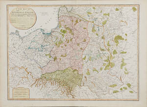
Map of Poland 1799
MAP OF POLAND. A New Map Of The Kingdom of Poland with its Dismembered Provinces and the Kingdom of Prussia, London, Laurie & Whittle, 1799. Läs mer...
1 600 SEK
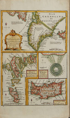
Bowen Grönland c. 1750
GREENLAND - ICELAND. BOWEN, Emanuel. A Map of Old Greenland or Öster Bygd & Wester Bygd... - A Map of the Islands of Ferro or Läs mer...
1 600 SEK
Europakarta 1950-tal
Vägghängd karta över Europa. Kartografi, reproduktion & tryck: Karl Wenschow G.M.B.H Munchen. Mått: 213 x 176 cm Konditionsrapport: Märken, mindre revor & bruksslitage, Inga övriga Läs mer...
500 SEK

South America map by Blome 1690
SCARE MAP OF SOUTH AMERICA. BLOME, RICHARD. A New Mapp of America Meridionale Designed by Monsieur Sanson Geographer to the French King... London, c. Läs mer...
1 700 SEK